LandPKS
Published in academic literature
App Summary
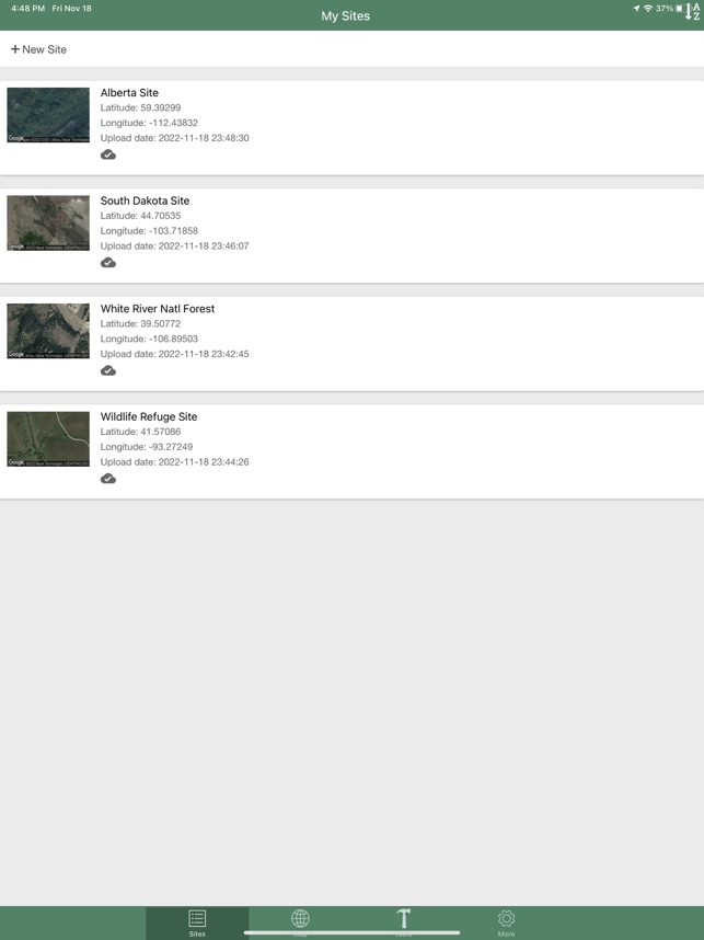
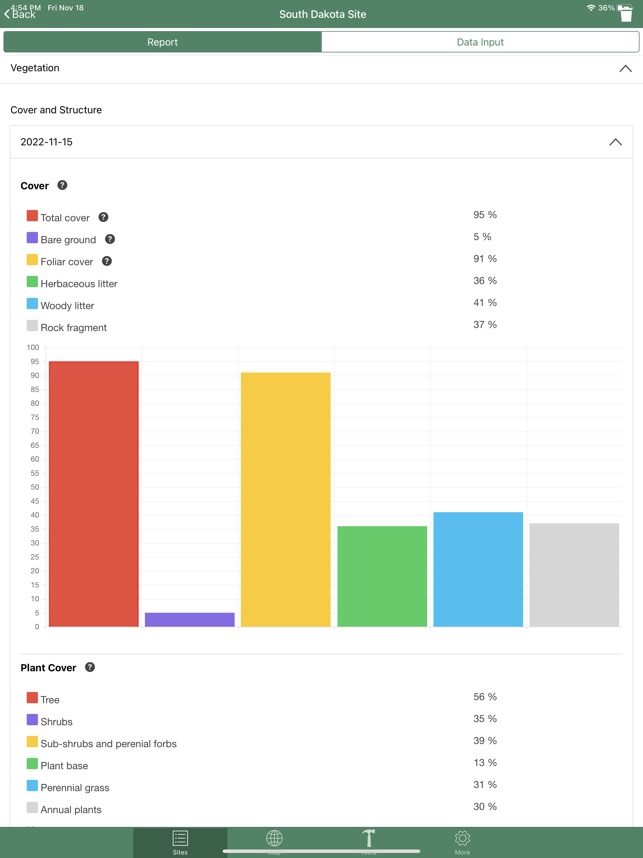
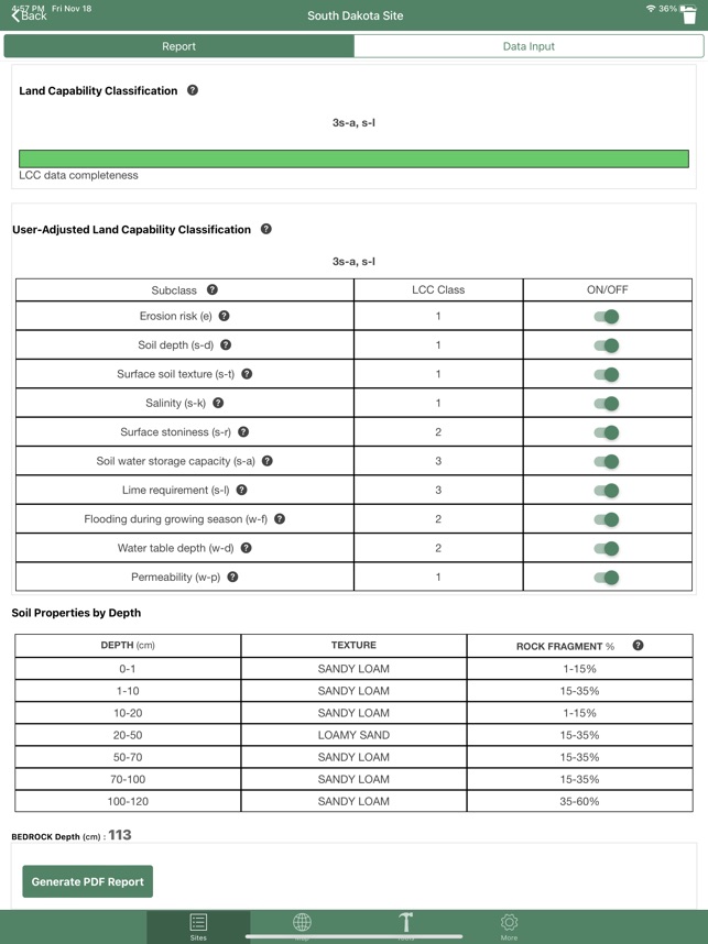
App Screenshots
Detailed Description
Functionality & Mechanism
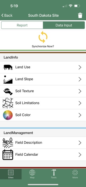
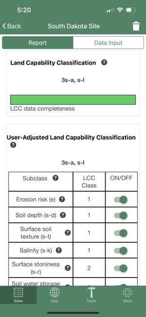
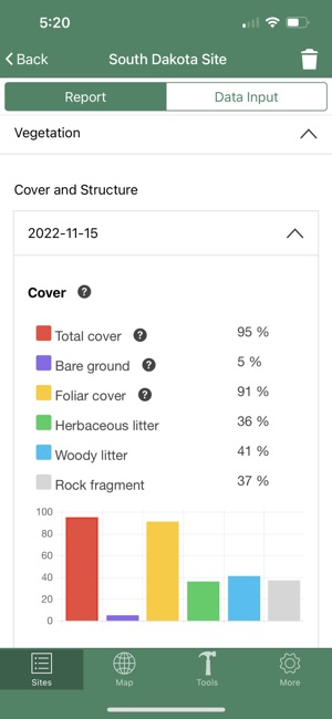
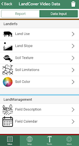
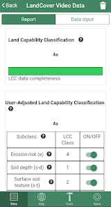
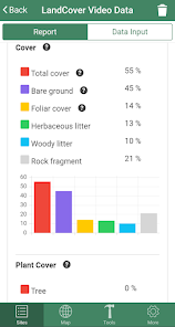
Developed by the USDA-ARS and its collaborators, LandPKS is a mobile decision-support system for sustainable land management. The application guides the collection of geo-located field data, including soil texture and vegetation cover, via distinct modules (LandInfo, Vegetation, SoilHealth). It integrates this user input with cloud-based climate, habitat, and soil databases to deliver site-specific land potential estimates and conservation practice recommendations. The interface functions offline, allowing for data collection in remote areas with subsequent synchronization.
Evidence & Research Context
- The system's design is detailed in foundational research articles, which establish its role in addressing global needs for sustainable land intensification and climate change adaptation.
- LandPKS leverages cloud computing to integrate user-provided point data with extensive geospatial information, enabling site-specific predictions of land potential based on soil, topography, and climate.
- Associated research outlines the system's utility for optimizing climate change investments by providing objective assessments of land potential and resilience to inform management strategies.
- The platform is designed to support evidence-based decision-making by matching land use practices to the sustainable production potential of a given site, thereby minimizing degradation risks.
Intended Use & Scope
This tool is intended for land managers, agricultural professionals, conservation scientists, and researchers. Its primary utility is for site-specific land assessment, long-term monitoring, and data-informed management planning. The system provides estimates to support decision-making and does not substitute for comprehensive laboratory soil analysis or professional consultation. Its habitat-matching functionality is geographically limited to the United States.
Studies & Publications
Peer-reviewed research associated with this app.
The Land-Potential Knowledge System (LandPKS): mobile apps and collaboration for optimizing climate change investments
Herrick et al. (2017) · Ecosystem Health and Sustainability
Describes the research-driven development of this appThe Global Land-Potential Knowledge System (LandPKS): Supporting Evidence-based, Site-specific Land Use and Management through Cloud Computing, Mobile Applications, and Crowdsourcing
Herrick et al. (2013) · Journal of Soil and Water Conservation
Describes the research-driven development of this appIn the Media
LandPKS Soil ID Goes Global - Terraso
Terraso expanded LandPKS Soil ID to enable global soil observation and identification, moving beyond its original United States-only functionality by integrating the Harmonized World Soil Database (HWSD 2.0) for international sites. The app now includes a new "Management" section for non-U.S. locations that describes soil maintenance practices and offers multilingual support in English, Spanish, and Ukrainian. Key partnerships include SENA's feasibility study in Colombia and Podilla State University's development of a Ukrainian-language manual for the platform.
Take to the field with LandPKS Soil ID
Terraso developed LandPKS Soil ID as a free and open source tool for sustainable land stewardship, enabling users to obtain soil and ecological site identification based on soil map predictions and field-collected data. The app builds upon the decade-long experience of the legacy LandPKS app and features project management capabilities for team collaboration and standardized data gathering. Currently available for U.S. sites, the developers expect to support sites anywhere in the world very soon.
Calling for Usability Testers for LandPKS Soil ID!
The LandPKS team developed a new LandPKS experience focused on Soil ID in the United States, with plans for a worldwide app version to follow. The team has reached the stage where they need usability testers to review key app experiences and provide feedback on features. Testers will have direct impact on the app's design and functionality while trying out LandPKS Soil ID features before public release.
LandPKS partners with Terraso to build new and improved suite of apps
USDA soil scientist Jeff Herrick partnered with Tech Matters in fall 2022 to rebuild LandPKS as an open-source app suite for iOS and Android, scaling to serve the next ten million potential users. The new suite will include a US Soil ID app, global Soil ID app, and Land Monitoring app, with the first release scheduled for late spring/early summer 2024. This next generation of LandPKS will operate within the Terraso platform, which equips land and community stewards with tools to manage data and communicate impact.
LandPKS: Learning How to Monitor Our Land Over Time and Discover Its Potential
USDA Agricultural Research Service soil scientist Jeff Herrick and LandPKS Program Coordinator Laura Hamrick developed LandPKS to help farmers gauge the production and conservation potential of their land through easy monitoring, tracking, and data-analysis tools. The mobile app enables users to identify soil types, monitor soil health and vegetation, track management practices, and monitor wildlife on agricultural operations. The National Center for Appropriate Technology produced educational materials for the app through the ATTRA Sustainable Agriculture program under a cooperative agreement with USDA Rural Development.
SoilID redesign provides a powerful key to unlock soil information, including SoilGrids access
The University of Colorado at Boulder developed LandPKS's redesigned SoilID feature to improve soil information accuracy for sustainable land management, using field measurements linked to existing soil maps. Jonathan Maynard, the soil scientist who led the redesign, explains "the value of soilID is that, through measuring a few key soil properties at a site and then linking that soil information to existing soil maps, we can minimize the uncertainty associated with those maps." The updated version includes improved visual interfaces and new access to SoilGrids v2.0, which provides soil property predictions at 250-meter spatial resolution.
LandPKS Mobile App: New Features
USDA developed LandPKS as a free mobile app to help farmers, ranchers, and land managers easily identify soil, access NRCS soil information, and monitor soil health and vegetation. In partnership with the Asombro Institute for Science Education, LandPKS recently released a three-lesson educational module that meets Next Generation Science Standards for grades 5-8. The app now includes new LandManagement and SoilHealth modules that provide a complete package for adaptive management without requiring complex software.
Got Soil? There's an App for That
ARS scientists in Las Cruces, NM, with support from the United States Agency for International Development, developed the Land-Potential Knowledge System (LandPKS) app to help farmers better monitor their soil and vegetative crop conditions for improved irrigation, weeding, and fertilization decisions. The app crowdsources local and scientific knowledge to inform risk management, helping to yield greater land productivity, economic return, and environmental enhancement. LandPKS is available for download on iOS and Android devices at LandPotential.org.
USDA ARS Online Magazine New Apps Provide Soil, Land, and Climate Data
Agricultural Research Service soil scientist Jeffrey Herrick developed LandPKS to give farmers and land managers critical soil and climate information, using cloud computing, digital soil-mapping, and GPS data. "The current apps can already help U.S. urban and small-tract land managers describe their soils without soil science training," says Herrick, who is based at the ARS Range Management Research Unit in Las Cruces, New Mexico. Domestic and international development organizations are already using the app to crowd-source local information needed to inform management decisions.
App Information
Category
Evidence Profile
Published in academic literature
Platforms
Updated
Jul 2025
© 2025 United States Department of Agriculture