Roman Forum Monuments 3D
Published in academic literature
App Summary
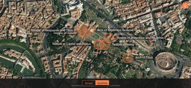
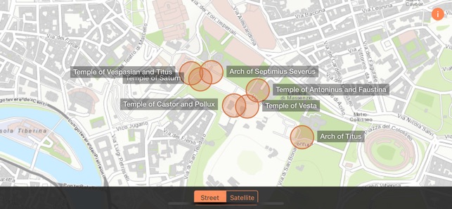
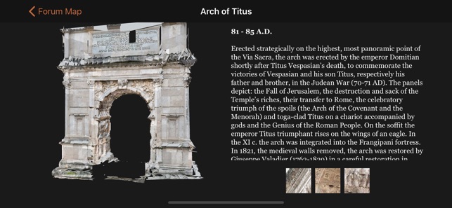
App Screenshots
Detailed Description
Functionality & Mechanism
Developed by the University of Notre Dame School of Architecture DHARMA team, this application delivers high-fidelity 3D visualizations of seven key monuments within the Roman Forum. The interface facilitates exploration through fully rotatable models, enabling examination of architectural details and perspectives not accessible to on-site visitors. Sessions involve navigating between a general site overview and close-up views of specific structures, leveraging a comprehensive digital archive. The system is designed for brief, focused engagement with each monument's virtual reconstruction.
Evidence & Research Context
- The application's 3D models derive from a multi-year digital documentation project of the Roman Forum conducted by a multidisciplinary research team.
- Researchers integrated multiple technologies, including high-density 3D laser scanning and photogrammetry, to produce a highly accurate point cloud model of the site.
- The underlying research established a comprehensive methodology for pre-site, on-site, and post-site digital documentation of complex World Heritage locations.
- Data processing involved rigorous noise reduction, precise alignment, and geometric feature extraction to create a unified, high-fidelity digital reconstruction for scholarly and educational use.
Intended Use & Scope
This application is intended as an educational and visualization resource for students, educators, researchers, and the general public. Its primary utility is to supplement on-site visits or academic study by providing detailed digital access to monument structures. It does not function as a comprehensive archaeological database and is not a substitute for expert-led historical analysis.
Studies & Publications
Peer-reviewed research associated with this app.
3D Documentation for Large Scale Monuments - The Roman Forum, Rome, Italy (2010–2025)
Krusche et al. (2025) · ISPRS Annals of Photogrammetry, Remote Sensing and Spatial Information Sciences
Describes the research-driven development of this app3D Documentation and Visualization of the Forum Romanum: A Dharma Project
Krusche et al. (2018) · EuroMed 2018 Conference Proceedings
Describes the research-driven development of this appIn the Media
School of Architecture's DHARMA project sheds light on Roman Forum
The University of Notre Dame School of Architecture's DHARMA lab developed Roman Forum Monuments 3D to document World Heritage Sites in unprecedented detail, using high-definition surveying lasers like the Scan Station and C10 along with GigaPan photography. Associate Professor Krupali Uplekar Krusche leads the student research team that combines 3-D documentation with meticulous hand measurements to create detailed blueprints of monuments and their urban settings. The technology identifies otherwise invisible areas of deterioration, allowing for repair and prevention of further damage to these historic structures.
Notre Dame team completes 3D Documentation of the Roman Forum
University of Notre Dame's School of Architecture developed Roman Forum Monuments 3D to accurately measure and document the historic Roman Forum site, using conventional methods and innovative Leica 3-D laser scanner technology. The students produced 27 scans, 30 panoramic views, and scaled detailed images in collaboration with Rome's Ministry of Heritage and Culture. The project aims to create watercolor renderings and a large-scaled colored map with sectional renderings showing the exact positions and measurements of the ancient ruins.
App Information
Developer
University of Notre DameCategory
Evidence Profile
Published in academic literature
Platforms
Updated
May 2019
© 2025 University of Notre Dame
Tags
Developer Links
Privacy PolicyRoman Forum Monuments 3D
Free