CrowdMag
Published in academic literature
App Summary
App Screenshots
Detailed Description
Functionality & Mechanism
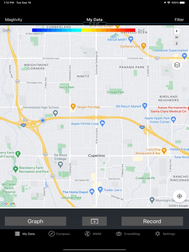
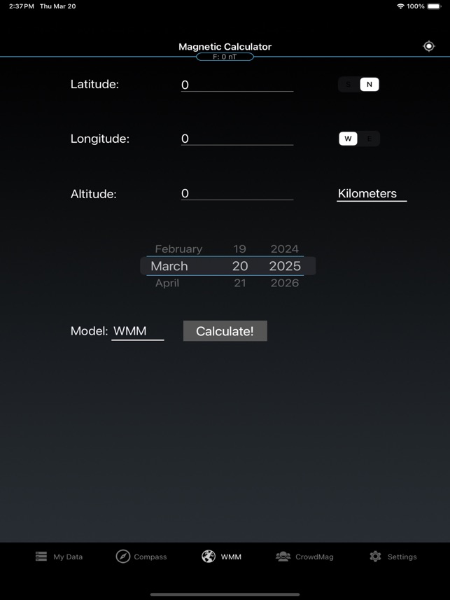
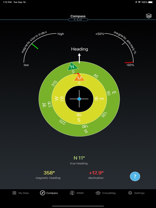
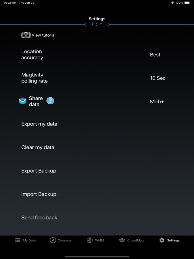
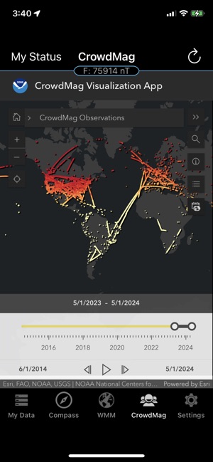
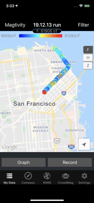
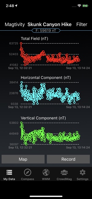
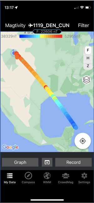
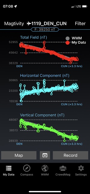
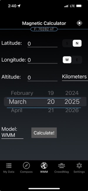
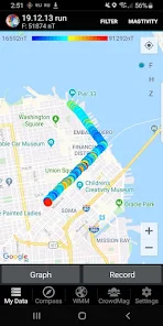
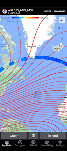
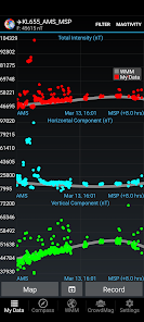
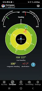
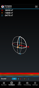
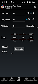
Developed by NOAA, CrowdMag leverages the integrated magnetometers in smartphones to function as a mobile geomagnetic data collection system. Users initiate recording sessions ("magtivities") to capture local magnetic field data, including Z (downward), H (horizontal), and F (total intensity) components. The interface facilitates data visualization via interactive maps and time-series graphs, and includes a magnetic calculator based on the World Magnetic Model. Optional data submission contributes to a global crowdsourced dataset for scientific research.
Evidence & Research Context
- An early analysis of over 12 million crowdsourced data points demonstrated that a global magnetic model derived solely from app contributions is generally consistent with established satellite-derived models.
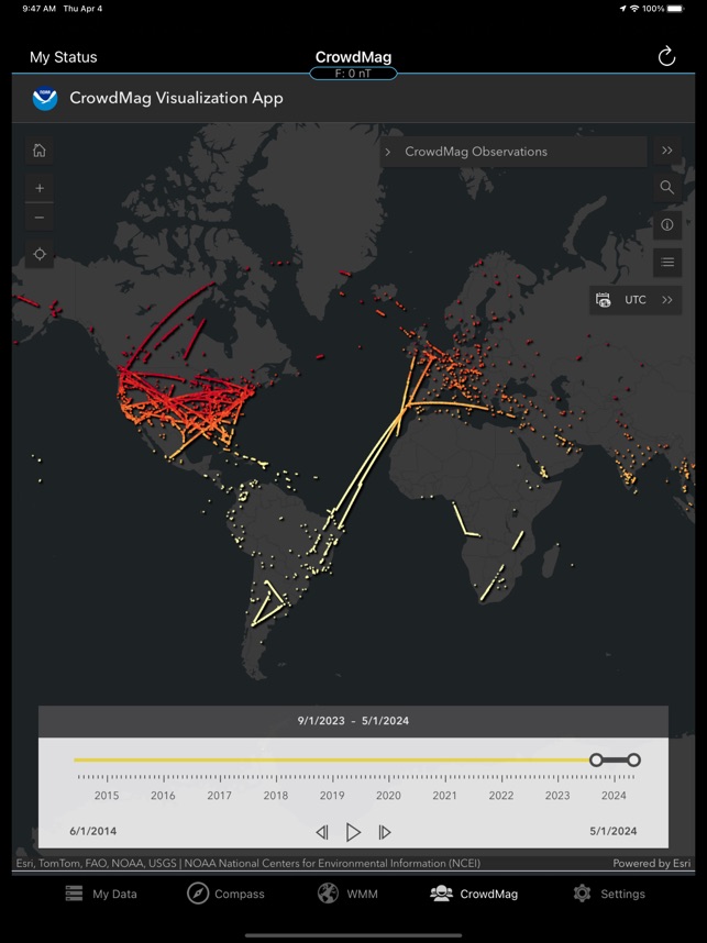
- The app enables the collection of ground-level magnetic data in densely populated regions with an unprecedented spatial resolution not achievable through traditional survey methods.
- Associated research details the novel application of a deep neural network (autoencoder) to denoise and calibrate the crowdsourced data, creating a high-quality, AI-ready dataset for geophysical analysis.
- The platform has been utilized as a citizen science tool since 2014, with data collection protocols designed in partnership with the University of Colorado's Cooperative Institute for Research in the Environmental Sciences (CIRES).
Intended Use & Scope
This app is designed for citizen scientists, educators, and the general public to contribute to geophysical research. Its primary utility is as a data collection tool for a large-scale project to improve global magnetic field maps. The system is not a substitute for professional-grade magnetometers, as individual measurements are subject to significant local interference and require aggregation and advanced processing for scientific use.
Studies & Publications
Peer-reviewed research associated with this app.
Building an AI-Ready Calibrated and Denoised Dataset of Magnetic Anomalies using Citizen Science Contributed CrowdMag Measurements
Opper et al. (2023) · AGU Fall Meeting
Describes the research-driven development of this appThe CrowdMag App – turning your smartphone into a travelling magnetic observatory
Saltus et al. (2017) · EGU General Assembly
Describes the research-driven development of this appIn the Media
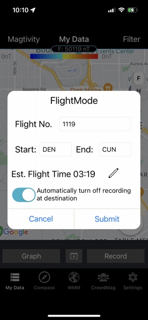
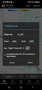
CrowdMag Flight Mode Tutorial
The National Centers for Environmental Information developed CrowdMag to collect magnetic field data through citizen science, using mobile phones' internal magnetometers to record measurements during flight journeys. The project has transitioned to CIRES at the University of Colorado, with the underlying data remaining available until this tutorial page is removed on September 7, 2025. Users must set their phones to airplane mode before takeoff and keep devices in consistent locations like shirt pockets or carry-on bags while avoiding metal objects during recording.
CrowdMag
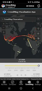
CIRES developed CrowdMag to collect high-resolution geomagnetic data using smartphone magnetometers from citizen scientists worldwide, providing a crowdsourced alternative to satellite magnetic field measurements. The app now includes a flight mode where users can collect magnetic data while flying, as airplane observations "fill in a large gap in magnetic data" between satellite and ground-based measurements. CrowdMag updates its interactive map hourly with crowdsourced magnetic data collected in the past 24 hours, following a 1x1 kilometer grid to ensure contributor privacy.
Become a Citizen Scientist with Our CrowdMag App
NOAA developed CrowdMag to help scientists obtain data about Earth's magnetic field using smartphone magnetometers and accelerometers that collect information during user "Magtivities." The app allows citizen scientists to send data from across the world, which NOAA combines with real-time solar wind data to create near-real-time models of Earth's magnetic field. The CrowdMag project has now transitioned to CIRES at the University of Colorado.
Become a Citizen Scientist with Our CrowdMag App
NOAA's National Centers for Environmental Information developed CrowdMag to help scientists obtain data about Earth's magnetic field, using smartphone magnetometers and accelerometers to collect geomagnetic measurements. The app allows users to complete "Magtivities" that send data to NOAA, which scientists then combine with real-time solar wind data to create near-real-time models of Earth's magnetic field. The CrowdMag project has transitioned to CIRES at the University of Colorado as of 2025.
Smartphone App Seeks to Make Navigation Safer
The Cooperative Institute for Research in Environmental Sciences and NOAA's National Geophysical Data Center developed CrowdMag to monitor Earth's magnetic field variations using smartphone magnetometers, addressing the limitations of GPS navigation systems. "All planes have magnetometersâÂÂhigh-tech compassesâÂÂbecause GPS can be jammed," explained scientist Manoj Nair, noting that traditional satellite data provides only fuzzy 3000-kilometer resolution while ships and planes achieve 56-kilometer resolution. The app aims to capture magnetic field details beyond current methods to improve navigation safety for planes, boats, and future delivery drones.
Crowdsourcing Earth's magnetic field
Dr. Manoj Nair from the Cooperative Institute for Research in Environmental Sciences developed CrowdMag to map Earth's magnetic field using crowdsourced data, taking advantage of cheap digital magnetometers embedded in smartphones. "Our goal is to see if low-quality but high-frequency magnetic measurements around the world can help us improve navigation systems," said Nair, who works in NOAA's National Geophysical Data Center. The app leverages over 1 billion smartphone users globally to provide simultaneous measurements that could help protect infrastructure from space weather damage.
Crowdsourcing Earth's magnetic field
Dr. Manoj Nair from the Cooperative Institute for Research in Environmental Sciences developed CrowdMag to map Earth's magnetic field using digital magnetometers embedded in smartphones worldwide. "Our goal is to see if low-quality but high-frequency magnetic measurements around the world can help us improve navigation systems," said Nair, who works in NOAA's National Geophysical Data Center. The crowdsourced approach leverages over 1 billion smartphone users to provide simultaneous measurements that could help protect infrastructure from space weather and improve navigation accuracy.
App Information
Developer
University of Colorado BoulderCategory
Evidence Profile
Published in academic literature
Platforms
Updated
Mar 2026
© 2025 University of Colorado Boulder