AppsFromResearch
ICESat-2 icon

ICESat-2

Evidence Tier:DOCUMENTED

Published in academic literature

For:Researchers & AcademicsGeneral Public & Enthusiasts

App Summary

This app allows the public and citizen scientists to track NASA's ICESat-2 orbital observatory, which uses advanced laser altimetry to measure changes in the elevation of Earth's ice sheets, land, and water. The associated research explains that the satellite's multi-beam design provides dense spatial sampling and determines local surface slope, overcoming limitations of previous missions to enable highly precise elevation measurements. By providing advance notice of satellite flyovers, the app supports public engagement and helps users anticipate when new elevation data will become available to contribute to a long-term record of planetary change.

App Screenshots

ICESat-2 screenshot 1 of 8ICESat-2 screenshot 2 of 8ICESat-2 screenshot 3 of 8ICESat-2 screenshot 4 of 8ICESat-2 screenshot 5 of 8ICESat-2 screenshot 6 of 8ICESat-2 screenshot 7 of 8ICESat-2 screenshot 8 of 8

Detailed Description

Functionality & Mechanism

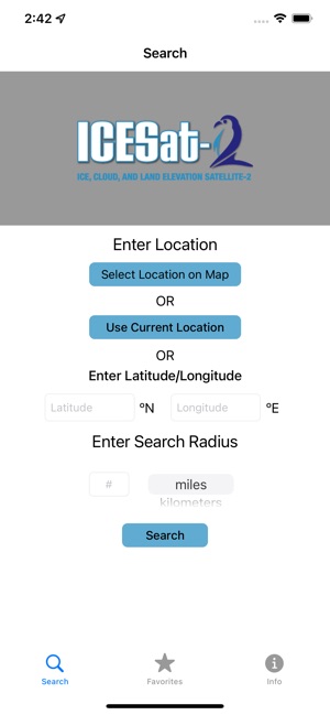
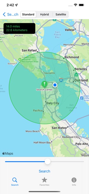
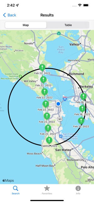
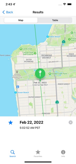
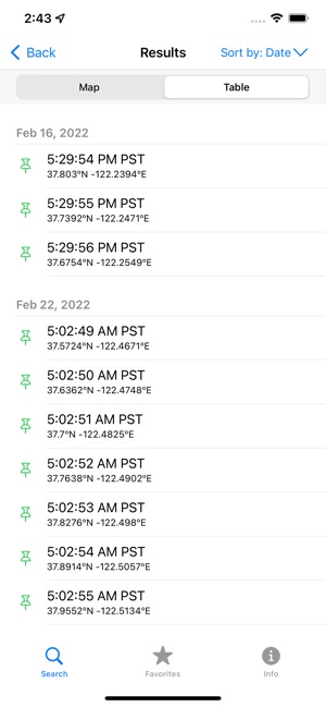
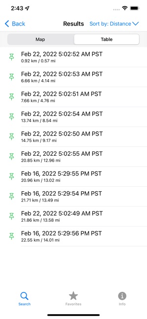
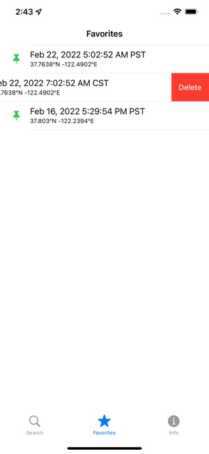
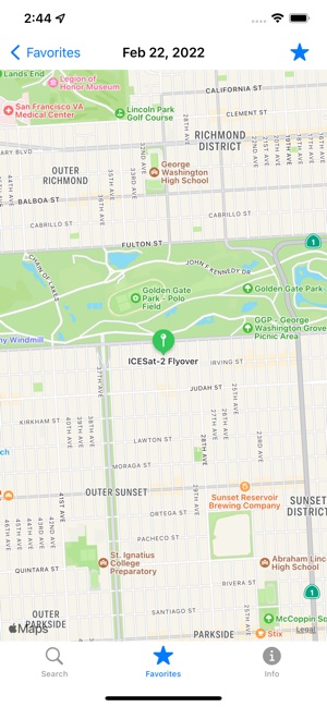
Developed by NASA, this application provides orbital predictions for the Ice, Cloud, and land Elevation Satellite-2 (ICESat-2). The interface facilitates the selection of a location of interest via an interactive map, latitude/longitude entry, or current device coordinates. The system then generates a list and map of future satellite flybys for that location up to three months in advance. The platform enables bookmarking of specific overflights to support planning for direct observation or citizen science campaigns.

Evidence & Research Context

The app supports engagement with the ICESat-2 mission, the scientific basis of which is detailed in associated research.

  • The primary scientific objective of the ICESat-2 mission is to quantify elevation changes in ice sheets and sea ice freeboard to understand the cryospheric response to climate change.
  • The satellite leverages an advanced laser altimeter system with six beams and single-photon sensitive detectors, enabling a high-resolution 17-meter surface footprint and dense 0.7-meter along-track sampling.
  • Its multi-beam pair configuration is specifically designed to determine local cross-track slope, improving elevation change accuracy over complex terrain like coastal outlet glaciers.
  • Mission data also supports research in terrestrial ecosystems by measuring vegetation height, land topography, inland water elevations, and atmospheric cloud properties.

Intended Use & Scope

This tool is intended for researchers, educators, and citizen scientists as a planning and public engagement utility. Its primary function is to forecast satellite transit times over specific geographic areas. The application does not provide or analyze the mission's scientific datasets. For access to elevation data, users must consult external repositories such as the National Snow and Ice Data Center (NSIDC).

Studies & Publications

1 publication

Peer-reviewed research associated with this app.

Non-Evaluative Reference

The Ice, Cloud, and land Elevation Satellite-2 (ICESat-2): Science requirements, concept, and implementation

Martino et al. (2017) · Remote Sensing of Environment

Referenced in academic literature; no direct evaluation of the app
The Ice, Cloud, and land Elevation Satellite (ICESat) mission used laser altimetry measurements to determine changes in elevations of glaciers and ice sheets, as well as sea ice thickness distribution. These measurements have provided important information on the response of the cryopshere (Earth's frozen surfaces) to changes in atmosphere and ocean condition. ICESat operated from 2003 to 2009 and provided repeat altimetry measurements not only to the cryosphere scientific community but also to the ocean, terrestrial and atmospheric scientific communities. The conclusive assessment of significant ongoing rapid changes in the Earth's ice cover, in part supported by ICESat observations, has strengthened the need for sustained, high accuracy, repeat observations similar to what was provided by the ICESat mission. Following recommendations from the National Research Council for an ICESat follow-on mission, the ICESat-2 mission is now under development for planned launch in 2018. The primary scientific aims of the ICESat-2 mission are to continue measurements of sea ice freeboard and ice sheet elevation to determine their changes at scales from outlet glaciers to the entire ice sheet, and from 10s of meters to the entire polar oceans for sea ice freeboard. ICESat carried a single beam profiling laser altimeter that produced ~ 70 m diameter footprints on the surface of the Earth at ~ 150 m along-track intervals. In contrast, ICESat-2 will operate with three pairs of beams, each pair separated by about 3 km cross-track with a pair spacing of 90 m. Each of the beams will have a nominal 17 m diameter footprint with an along-track sampling interval of 0.7 m. The differences in the ICESat-2 measurement concept are a result of overcoming some limitations associated with the approach used in the ICESat mission. The beam pair configuration of ICESat-2 allows for the determination of local cross-track slope, a significant factor in measuring elevation change for the outlet glaciers surrounding the Greenland and Antarctica coasts. The multiple beam pairs also provide improved spatial coverage. The dense spatial sampling eliminates along-track measurement gaps, and the small footprint diameter is especially useful for sea surface height measurements in the often narrow leads needed for sea ice freeboard and ice thickness retrievals. The ICESat-2 instrumentation concept uses a low energy 532 nm (green) laser in conjunction with single-photon sensitive detectors to measure range. Combining ICESat-2 data with altimetry data collected since the start of the ICESat mission in 2003, such as Operation IceBridge and ESA's CryoSat-2, will yield a 15 + year record of changes in ice sheet elevation and sea ice thickness. ICESat-2 will also provide information of mountain glacier and ice cap elevations changes, land and vegetation heights, inland water elevations, sea surface heights, and cloud layering and optical thickness.
... Read More

ICESat-2

Free